Friday, 31 March 2023

Great Inagua to Acklins Islands

Hi everyone,

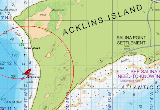
Last night we sailed the 86nm NNW from Matthew Town to Jamaica Bay (also known as Datum Bay).  The passage started with an hour's motoring to get out of Great Inagua Island's lee.  Then we found the ENE breeze and were away.  We had a fast beam reach in 16-18 knots, gusting to 24 knots.  After rounding Castle Island we were close hauled for an hour before motoring into the anchorage.

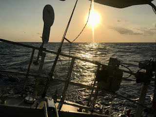
Last night's sunset

Here are the usual plots..

Overall Track

Arrival Track

Graphs

Here are the vital statistics...

  • Distances/Speeds
    • Route Distance = 86nm
    • Log Distance = 96nm (probably over-reading)
    • Track Distance = 87nm
    • Duration = 15 hours
    • Average boat speed = 6.4kt (probably over-reading)
    • Average ground speed = 5.8kt
    • Minimum boat speed = 3 kt
    • Maximum boat speed = 6.8 kt
  • Weather
    • Minimum wind speed = 4kt
    • Average wind speed = 17kt
    • Maximum wind speed = 19kt (gusts to 24kt)
    • Apparent wind angle range = 40 to 110
    • Seas up to 1m
    • Swell up to 1m
    • Mostly clear sky with scattered small cumulus and rare banks of broken cumulus 
  • Engine
    • Total = 2 hours (13%)
The last hour's motoring was a good opportunity to test the engine with its new mounts.  We were pushing in to 20 knots of wind so had 24 knots over the deck.  And there was a sharp 075m chop.  The engine handled it easily at 2000rpm.  We usually motor at lower revs so this was a good opportunity to 'blast clean' the exhaust manifold and mixing elbow.

The photo below illustrates our navigation setup in inshore waters.  OpenCPN on the foreground screen, iPad running Vesper's Cortex AIS app and WilhelmSK displaying live SignalK data on the display in the background (on the main bulkhead).  We're using the very detailed and informative Explorer charts here in the Bahamas.

Navigating!

Jamaica Bay (aka Datum Bay) seems a pretty good anchorage.  Less rolly than Matthew Town, but swell is getting into the bay so it's not roll-free.  We're anchored in 6m over sand at 22 11.88N 74 17.00W.  We could clearly see the bottom from about 15m depth.

Castle Island and its lighthouse

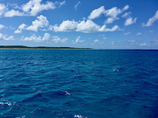
View S from anchorage

View N from anchorage

Trust all's well where you are.


Matthew Town

Hi everyone,

This afternoon we'll be departing our first port of call in the Bahamas.  Matthew Town on Great Inagua Island is a quiet place of about 900 people.  Clearing in on Tuesday morning was very simple given we'd already used Click2Clear to pre-arrange our 1 year Cruising Permit.

Matthew Town dawn

HMBS Nassau Patrol Boat in port

USCG helo passing by

On Wednesday we dinghied ashore to explore.  We walked about 1nm along the beach to the lighthouse on South West Point.  A group apparently from the HMBS did the same and some weren't enjoying their walk in the sun.

The lighthouse

The lighthouse's staircase has a few steps missing

The town was quiet.  But just about everyone we came upon gave us a proper Bahamian welcome - a wave, a smile and a big 'hello'.  The colours here are bright and vibrant too.  We found the general store and bought some bread.  They had plenty of the locally produced Morton Salt in stock.

Colourful signage

Nice beach with Zen Again at anchor

Walking around the town we found a real mixture of buildings.  Some are obviously abandoned.  Some are well cared-for, some are very new.  Most are colourful.  The churches are beautiful and very well maintained.

Abandoned building

Methodist Church

Catholic Church

Colourful Cop Shop

It's a shame we can't spend longer exploring the island as a whole.  Tempus fugit and we have a date with the US Embassy in Naasau in a few weeks.  Tonight we'll be departing towards Acklins Island, about 85nm NW.

Matthew Town sunset

Trust all's well where you are.


Wednesday, 29 March 2023

Jamaica to Bahamas Passage Summary

Hi everyone,

We arrived at Matthew Town, Great Inagua Island, Bahamas at 2130 last night after a nice reach across from the Windward Passage.  We are anchored in 6m over sand at 20 57.01N 073 40.82W.  Rolly, just as it says in the guides!

Zen Again anchored off Matthew Town

Here are the usual plots..

Track

Arrival Track (on Explorer chart)

Sailing Graphs

Electrical Plots (Orange line shows engine on)

Here are the vital statistics...

  • Distances/Speeds
    • Route Distance = 240nm (direct)
    • Log Distance = 334nm
    • Track Distance = 286nm
    • Duration = 2 days 14 hours (62 hours)
    • Average boat speed = 5.4kt
    • Average ground speed = 4.6kt
    • Average day's run = 128nm (through the water)
    • Best day's run = 133nm (5.5 kt)
    • Minimum boat speed = 3 kt
    • Maximum boat speed = 7 kt
  • Weather
    • Minimum wind speed = 3kt
    • Average wind speed = 10kt
    • Maximum wind speed = 14kt (gusts to 18kt)
    • Apparent wind angle range = 40 to 90
    • Seas up to 1m
    • Swell up to 1.5m
    • Broken small cumulus gradually clearing to a cloudless sky
  • Engine
    • Total = 23 hours (37%)
  • Failures
    • ProFurl furler not accepting line into drum cleanly (2nd time in 10 years)
  • Stars
    • The engine (including its new mounts)
    • Autopilot (Raymarine SPX5)
    • Starlink for accessing GRIB files and email
    • Icom IC-7300 SSB for 12 hourly position reporting net with friends
    • the cook!

We did a lot of motoring on this passage!  Not what we'd hoped for but it wasn't a surprise.  The motoring was an excellent test of our new engine mounts.  And the sailing we had was good, marred only by the furler problem.  This required me to go forward to sort it out or to guide the furling line onto the drum.  Copped a greenie once which gave me a full body shower.

The stats show we encountered a lot of current, adding about 50nm to our trip.  That's presuming our log isn't over-reading.  Predictions showed a lot of cross-current which seems to justify the extra miles.  Our heading was frequently 20-30 degrees off our CoG (course over ground).

Reaching north toward The Bahamas

Ready for arrival

Arrival into the Matthew Town anchoraage at night was very straightforward at night.  There are no offlying dangers.  We have the 
OpenCPN Explorer electronic charts of The Bahamas.  They are excellent - practically mandatory here.

This morning I dinghied into the harbour.  In the middle there is a small craft jetty where dinghies can be secured.  Then it was a 100m walk to the pink building on the southern side of the harbour.  There I found a gentleman who called customs & immigration, and gave me arrival cards to complete.  The officials turned up within a few minutes.

The customs man had printed and stamped the Cruising Permit we applied and paid US$300 for online.  That gives us one year, multiple entry cruising in the country.  The immigration lady took our passports and completed arrival cards away and returned 15 minutes later with everything completed.  We paid a US$40 immigration fee.

Small craft jetty in Matthew Town Harbour

Pink building for clearing in/out

Yes, it is rolly!

It's great to be in The Bahamas!  We have about 4 weeks to cruise our way to Nassau where we will have our US visa interviews.  Looking forward to sailing downwind again!

Tuesday, 28 March 2023

Bahamas Inbound

Hi everyone,
At 1200 today we were at 20 06N 073 47W steering 040M, motoring at 5 knots. Sunny with a clear sky. Wind 7G10 from the E. Our noon to noon run today was 124nm by the log.

Yesterday we motored from 1130 to 1930. Next to no wind and a sloppy sea. Then a new NE breeze came in and lasted until midnight. It got up to 12G17 knots and we used it to sail E. But by midnight it had faded and the motor came back on. We tacked N at that point.

We gave sailing another try at 1000 this morning when a new breeze seemed to be setting in. But that only lasted for an hour. This afternoon we finally cleared the Windward Passage and a nice 9G12 knot E breeze settled in and we were back sailing.

We are out of the Caribbean Sea! At 1500 we have about 35nm to go to Matthew Town.

Monday, 27 March 2023

Jamaica Outbound

Hi everyone, 

At 1200 today we were at 19 15N 075 08W steering 080M, motoring at 5.5 knots. Sunny sky. Wind 3G6 from the S. Our noon to noon daily run was 133nm by the log.

Yesterday afternoon we had a nice SE breeze which allowed us to make good easting.  By midnight the wind had backed to NE and we turned with it, taking the chance to make some northing.  All just about close-hauled, perhaps cracked a little to keep Zen Again moving well through the swell.

At midnight we dropped a reef in the main when apparent wind rose above 16 knots.  That was much more comfortable.  We had one furl in the yankee.  At 0730 we shook out the reef and were back under full sail.  We tacked from tracking 000M to 150M, then back again.  We have an adverse current which is slowing our progress.

Overnight we had a crescent moon initially which was very bright.  After it set we had an amazing starscape to watch.

This morning there’s barely a cloud in the sky and it’s a nice day.  Except that the wind is very light.  Until 1130 we were beam reaching E in light airs.  The swell from the NE wasn’t helping, and nor was the current.  So at 1130 the donk went on and we’re making good progress.  When we start the engine we have to give her a burst astern to throw off accumulated weed on the prop.  The AutoProp is great, but as a feathering type it’s a good weed catcher.

Wind should return this evening so hopefully we won’t be motoring for very long.

Trust all’s well where you are.

Sunday, 26 March 2023

Jamaica Departure

Hi everyone,
At 1200 today we were at 18 25N 076 16W steering 070M, sailng under full main and yankee at 5.5 knots. Sunny with a few small cumulus. Wind 10G14 from the ESE. Our run from departure at 0730 to noon today was 21nm by the log.

We departed Port Antonio in a very light rain shower. Passed a Jamaican coast guard cutter in the harbour channel. Hoisted sail once through the channel then set course close-hauled on starboard tack. Initially it was very lumpy but it has been gradually settling down.

We cleared out yesterday afternoon for Matthew Town on Great Inagua Island in the eastern Bahamas. To get there we need to sail through the Windward Passage, and it is certainly to windward for us! But Zen Again's tramping along well and at the moment there's a nice bit of S in the E wind. We don't expect that to last but it's nice while it's here.

Our passage to Matthew Town is about 260nm. So it's similar to a Geraldton Return in distance and point of sail. Different since we have a 1 knot current on the nose until through the Windward Passage. Once through the Passage we should be able to ease sheets onto a reach.

Trust all's well where you are!

Saturday, 25 March 2023

Jamaica Adventures

Hi everyone,

We've been in Jamaica for 11 days and are now cleared out for departure.  With apologies to 10CC "we don't like Jamaica - oh no - we love her!".

Appleton Estate tour

We spent our first week in Port Antonio doing boat jobs and exploring the town.  The locals were very friendly and helpful too.  The only exception was one well-dressed gent who demanded money "or I'll knife you".  In the absence of a knife we thanked him for the offer and walked away.

Port Antonio has several supermarkets.  None are large but they're pretty good.  We visited the Roots 21 cafe for a Seafood Boil.  Awesome.  Biggest and best crabs we've ever had.

Zen Again in Port Antonio's Errol Flynn Marina

Very nice local ice cream!

Local market

Seafood Boil at Roots 21

We hired a rental car for two days.  Our plan was to drive around the island and it worked out well.  About 550km total.  On day one we drove along the north coast to Montego Bay, stopping briefly in Ocho Rios.  Didn't think much of the latter but enjoyed a very nice lunch at the Montego Bay Yacht Club.  The road along the north coast is pretty good.

Manicured beach at Ocho Rios

Montego Bay Yacht Club

Lunch at MBYC

MYC clubhouse

From Montego Bay we drove to the Appleton Estate rum distillery on the south side of the island.  This was on the B6 road and was the most challenging drive with heavily pot-holed, narrow, twisty roads.  Lots of fun!  Along the way we noticed many very well-kept churches.  Jamaica is quite a poor country but its people are generally up-beat and most are church-going.

Into the hills

One of so many well-kept churches

Nice countryside

We arrived at Appleton Estate just in time for the their final tour of the day.  The tour is quite expensive but includes a welcome rum cocktail, very interesting tour and rum tasting.  We saw a donkey crushing sugar cane, then I volunteered to try it myself.  Two of us kept the cane feeder busy as he kept doubling over the cane in an attempt to slow us down.

'Tis good stuff

Appleton Estate welcome hall

Sugar cane crushing by donkey

Model of three step Copper-based distillation

There's lots of it (most aged in Kingston)

Very nice tastes

From the distillery it was a very short drive (by design) to our guesthouse where we stayed overnight.  Our host took us out to buy locally made jerk chicken and pork.  Yummy!

Authentic Jerk Chicken & Pork

On day two we drove from our guesthouse in the SW of the island to Kingston.  Pretty good roads, with the second half on a toll freeway.  We drove through Kingston and out onto the peninsula where the airport and the Royal Jamaica Yacht Club are located.  Like Montego Bay this YC was also very nice and we had a good lunch there.

RJYC bar and pool

RJYC clubhouse

From there we drove north out of Kingston on the B1 across the Blue Mountains via Strawberry Hill to Buff Bay where we rejoined the north coast road.  The B1 was pretty good on the way up, perhaps since a lot of tourist go up there from Kingston.  But the north side was pot-holed and as much fun as the B6.

Along the way we stopped for an authentic Blue Mountains coffee in the Blue Mountains.  It really is VERY good coffee.

Into the Blue Mountains

View back towards Kingston

Up into the clouds at about 4000' ASL

Blue Mountains coffee ...

... for all!

We've really enjoyed our time in Jamaica.  Highly recommended!

Trust all's well where you are.