Showing posts sorted by relevance for query kap. Sort by date Show all posts

Wednesday, 17 December 2025

New Zealand GoogleEarth KAP Charts

Hi everyone,

This is another technical post.  Last week I created a set of about 400 New Zealand anchorage, mooring and marina waypoints, primarily for use in OpenCPN.  They're publicly available and described here.  This week's task was to create GoogleEarth KAP satellite image 'charts' for them all.  KAP charts can be displayed in OpenCPN.

Viewing Zen Again's location in OpenCPN using KAP charts

Many sailors using satellite imagery in OpenCPN have abandoned KAP charts in favour of MBTILES charts.  The latter allow one to zoom in and out, viewing varying levels of detail while doing so.  I prefer to only use satellite imagery when zoomed in on a small area, for example a narrow pass or a small bay.  KAP files are also much smaller, for example MBTILES for all New Zealand is about 6GB while my KAP files are about 400MB.  Both formats have their uses.

Read this post to learn about our KAP library and how to use satellite imagery.

The KAP library is on Dropbox here and the file is Australasia_NewZealand.zip.

The quality of satellite imagery varies enormously - regardless of format.  Below are a series of KAP charts in OpenCPN.  They range from very clear to 'clear as mud'.  Many of the Fiordland images are very dark due to poor light in the fiords - they're surrounded by tall mountains after all!

Napier Harbour

Sailor's Rest on Stewart Island

Kelly's in Fiordland

Alice Falls in Fiordland - note the water course

Harrison Cove in Fiordland

If you look carefully at the image below you'll see lots of small red 'dots'.  They're actually rectangles showing the location of each chart.  The set includes all main cruising areas, but of course no set is exhaustive.


All of these KAP charts were created using the VFKaps OpenCPN plugin.  This fantastic tool makes the process very easy.  The 'VF" in VFKaps refers to VentureFarther, a web site setup to assist cruisers.  To create KAP files using the plugin you need to pay a US$20 subscription to VentureFarther.  This buys you the API key required by the plugin.  Worth every cent!

If you find our KAP file library useful consider donating using the button at the top of this page.  Alternately Buy Us A Coffee.

Trust all's well where you are!


Wednesday, 15 April 2015

CM93 Charts and GoogleEarth Imagery on iPad

Hi everyone,

!!! NOTE !!!
From SEAiq version 4.0 (released December 2015) CM93 charts are no longer supported.

On Zen Again we have been using CM93 vector charts and KAP raster "charts" (produced from GoogleEarth imagery using GE2KAP) in OpenCPN as an aid to navigation.  See our blog from 2012 on the latter.  Ever since then we have been under the impression there was no software to present this information on our iPads.  During our cruise through SE Asia we found no-one who knew of such software.

Today we discovered we were all wrong!  Thanks Carolyn for pointing us in the right direction.  There _is_ an app which can display CM93 and KAP charts on iPad.  SEAiq is the answer and it is brilliant.

Within minutes of downloading and installing the app I had installed our CM93 charts.  A few minutes later I had a few KAP files installed too.  Once aboard Zen Again it took only a few minutes to configure SEAiq to accept AIS, GPS and instrument data from our Vesper XB-8000 AIS over WiFi.

The two screenshots below show example KAP and CM93 views, both of Direction Island in the Cocos-Keeling Islands.  Changing between the two involves switching one setting (Raster Charts On/Off).

KAP file GE image of Direction Island (Cocos-Keeling)
CM93 chart of Direction Island (Cocos-Keeling)
The two screenshots show the presentation of CM93 charts in Fremantle with WiFi data enabled.  The Status Bar the top of the screen is now populated, Zen Again is the black ball and AIS targets are shown.
Fremantle
Success and Fishing Boat Harbours close up
Here's another view with CM93 chart detail set to "Basic".  This reduces clutter to make AIS targets clearer.
Simplified CM93 View of Fremantle and Gage Roads
SEAiq has a good table view of AIS targets.  The information page for each target is very detailed.

AIS Targets Page
Individual AIS Target Page
SEAiq also supports email requests for and display of GRIB files.  It will generate an email request to send to SailDocs.  It would be nice to see the range of GRIB providers expanded.

Weather Page
SailDocs GRIB Request Email
I later loaded a set of several hundred KAP files.  This wasn't as straight-forward as I had hoped but I eventually got them all installed and working.  I used iTunes to transfer both CM93 and KAP files.

The two issues I have found so far are:
  • Some zip files containing kap files are not accepted by SEAiq, despite successfully loading the same set of files individually
  • Unsurprisingly SEAiq gets a little slow if a large set of KAP files is loaded
Update (20 April):  The zip issue has been identified by SEAiq as the presence of Mac OS X hidden files in zip files.  These files have names like __MACOSX and .DS_Store and can be searched for in zip files using the command [unzip -l <filename>] (without the square brackets).  If such files are found use the command [zip -d "__MACOSX*" "*.DS_Store*”] to remove them from the zip file.  The next release of SEAiq will ignore these files.

It is surprising that SEAiq is not listed when one searches for "marine navigation" in the App Store.  I think that explains why we've never heard of it before.  I have mentioned this to the SEAiq folks.

Update (20 April):  SEAiq will be listed under "marine navigation" from its next release in the App Store.

One thing's for sure - SEAiq is a very useful iPad app for sailors who need their charts supplemented by GoogleEarth imagery.  It is a very nice chartplotter generally, but the support for both CM93 and KAP charts sets it apart.  Very cool.

Thursday, 23 April 2015

GoogleEarth KAP library for OpenCPN and SEAiq

Hi everyone,
For several years I have been creating and swapping GoogleEarth imagery for use in the free chartplotter OpenCPN.  The imagery is captured using GoogleEarth and GE2KAP while online and produces KAP files for use offline in OpenCPN.  Perfect as an extra aid to navigation in poorly charted areas, as described in my 2012 post here.

All the imagery I have created and which I have collected from others is intended to be shared.  I have shared on an individual basis so far.  The data is now available online.

The library is on Dropbox here.

For those who return to the library looking for new or updated information: click on the "Modified" column heading in Dropbox.  This will sort the files by modification date with most recent at the top.

First download and store somewhere safe the file "_readmefirst.txt".  Keep it for offline use.  The contents of the file are below since it provides much of what I need to explain here.  Please read on!

=======================================================================
                               A Guide to using 
                     Zen Again's Dropbox KAP File Library
                        for use with OpenCPN and SEAiq
======================================================================= 

Origin and Further Distribution
-------------------------------
The KAP files in this library have been generated by various cruisers 
including myself.  All who have provided files to me have indicated their 
willingness for me to distribute them further.  The only proviso we make is 
that they be further freely shared to assist other cruisers.

Intended Applications
---------------------
The KAP files have been tested in OpenCPN and SEAiq using the latest versions
available at the above date.

File Naming
-----------
The ZIP files are named in the following formats:
A. <Region>_<Country>_<Locality>.zip or
B. <Australia>_<State>_<Locality>.zip

File Size
---------
The KAP files are split into modest size ZIP files for two reasons:
1. To allow the selection of specific KAPs of interest without having to 
   download large files.
2. To allow for use in SEAiq which (since it runs on tablets) could be 
   slowed dramatically if many hundreds of KAPs are loaded.

Installation
------------
For those with pre-existing OpenCPN chart folders such as:
  MacOSX:  /user/Shared/charts/opencpn/ge/<region> or 
  Windows: /Users/Public/charts/opencpn/ge/<region> where region is Asia, Indian etc
simply add to (or replace) the existing contents with the contents of the 
ZIP files you download here.

For those with pre-existing SEAiq chart ZIP files simply add my zip files 
nearby and use iTunes to add them to (or later delete them from) SEAiq. 

Using KAP Files
---------------
See the following blog posts:
Using GoogleEarth Imagery for Marine Navigation
  http://yachtzenagain.blogspot.com.au/2012/10/using-googleearth-images-for-marine.html

Making KAP Files
  http://yachtzenagain.blogspot.com.au/2012/04/simple-guide-to-installing-and-using.html

GoogleEarth Imagery on iPad
  http://yachtzenagain.blogspot.com.au/2015/04/cm93-charts-and-googleearth-imagery-on.html

GoogleEarth Imagery on Raspberry Pi
  http://yachtzenagain.blogspot.com.au/2014/10/super-cheap-cruising-chartplotter-and.html

Updates
-------
The library will be updated from time to time.  Individual files may be updated 
so check the date stamp of files you use.  New files may be added so check for 
new files in your region of interest.

Additions
---------
If you would like me to add your images to this library just let me know.

Remember!!!
-----------
GoogleEarth images FADE TO BLACK a few hundred metres from land!!!

=======================================================================

Now to add some help for installing charts in OpenCPN and SEAiq.

Installing and Configuring in OpenCPN
  1. Download all the ZIP files of interest from Dropbox - usually to your downloads folder.
  2. Identify where your existing charts are located (Shown in OpenCPN in Options => Charts => Chart Files.  [I locate my KAP charts in /Users/Public/charts/opencpn/ge on Windows and /Users/Shared/charts/opencpn/ge on Mac OS X]
  3. If they don't already exist, create folders for regions (eg SEAsia, Australia, IndianOcean or similar) in the folder you intend to use for your GE imagery.
  4. Unzip (on Windows use right-mouse-button => Extract To) each of the downloaded ZIP files to the appropriate region folder.  Unzipping will create a folder for the <Locality> described in the readme file above.
  5. Check that your folder structure looks something like "charts/opencpn/ge/Australia/Abrohlos" with .kap files in the Abrohlos folders.
  6. If you wish you can add an extra layer of folders to fully mimic the file naming structure in the readme.  This depends on how you wish to use Chart Groups - read on!
  7. In OpenCPN go to Options => Charts => Chart Files.
  8. You should see a list of chart folders OpenCPN is using, often including a folder "CM93".  If you have some KAP files already loaded then there should be another folder.
  9. Click the Add Directory button, browse to the folder where your new KAP files exist, highlight the folder then click on Open.  I suggest highlighting the region folder (eg Australia, SEAsia etc), not the locality folder (unless you want a Chart Group for each locality).
  10. Tick the "Force Full Database Rebuild" switch and click OK.  OpenCPN will then scan all your chart directories building its chart index database, which may take a minute or three.
  11. When the rebuild finishes, zoom way out (using the "-" key) so you can see the regions covered by your GE imagery.  You should see small red boxes which show the location of each image.  If not go into Options => Display, turn on Show Chart Outlines, click OK and look again.
  12. To view a GE image zoom in over one of the red boxes and centre it in the screen.  At the bottom of the OpenCPN window you should see blue "tabs" appear to the left of the yellow tab which was there before.  The rightmost tab is always the real (vector) chart.  Others are image (raster) charts.  Click on the leftmost tab to open what is usually the best image for the location.
  13. Sometimes OpenCPN zooms when you change from one "tab" to another.  IMHO this is a bug.
Configuring Chart Groups in OpenCPN
  1. Go to Options => Charts => Chart Groups.  In the Chart Groups panel you will see an All Charts tab.  We are going to add more so that the number of GE images OpenCPN is dealing with can be controlled despite them all being installed.  I usually define Chart Groups for a region of the globe (SEAsia, Australia etc).
  2. To create a Chart Group click on New Group and give it a name (for example GEseasia) and click OK.  Then click on your vector charts (often CM93) folder and click Add.  Click on the relevant GE chart folder and click Add.  You may wish to create a Chart Group called CM93only with no GE folders included.
  3. When finished click OK to exit Options.
  4. In OpenCPN zoom way out (using the "-" key) so you can see the regions covered by your GE imagery.  You should see small red boxes which show the location of each image.
  5. Right mouse button, move over to Chart Groups and right into the list of groups.  All Chart Groups is probably ticked.  Click over another group and you should  see a set of red boxes disappear.  Chart Groups are a nice way to manage what images are accessible.  Once familiar with all this you can turn off Show Chart Outlines since drawing them seems to keep OpenCPN quite busy.
Installing and configuring in SEAiq
  1. Download all the ZIP files of interest from Dropbox to the computer you use to sync your iPad - usually to your downloads folder.
  2. Identify where your existing charts are located.  [I locate my KAP charts in /Users/Public/charts/opencpn/zip on Windows and /Users/Shared/charts/opencpn/zip on Mac OS X].
  3. Connect your iPad to the computer and let it sync if it wishes.  Open iTunes if it doesn't open automatically.
  4. Click on the iPad symbol at top left of iTunes, then click on Apps on the left.
  5. Scroll all the way down past the Apps list to the File Sharing list.
  6. Click on SEAiq Open in the File Sharing list on the left.
  7. On the right you now have a SEAiq Open Documents list which may be empty.  At the bottom of the list click on Add.  Browse to the folder containing the downloaded ZIP files.  Select those you wish to install in SEAiq and click Add.  You will see a progress bar at the top of iTunes.
  8. On the iPad open SEAiq and click on Charts at bottom right.  Wait for it - the response can take a few seconds if you downloaded ZIP files containing hundreds of images.
  9. When the Charts page loads you should see a row for each ZIP file, with each showing its size and number of KAP (image) files it contains.
  10. Now you see the logic behind the file naming scheme!
  11. Note that you download CM93 charts in a similar way, just select your CM93 ZIP file in iTunes and Add it to SEAiq.
  12. Click on Navigate and pan/zoom to the locality of the imagery you transferred.  You should see faint orange boxes delimiting the images.
  13. To change between vector (CM93) and raster (KAP image) charts click on the Settings tab and and move the slider on the Raster line in the Charts section, then return to Navigate.  You may need to pan slightly to have the page redraw.  Hey Presto!
  14. ZIP files can be removed from SEAiq in either iTunes or on the iPad directly in the Charts page. 
Hope the above helps you install the imagery.  Let me know if you like it and if you want more.

Here are two screenshots from SEAiq showing Cape Vlamingh on Rottnest Island WA.  Breaks on the reefs are clearly visible.
GE image of Cape Vlamingh, Rottnest Island, WA in SEAiq
Chart (decluttered) of Cape Vlamingh, Rottnest Island, WA in SEAiq

Friday, 15 October 2021

GoogleEarth KAP Library Update

Hi everyone,

It has been years since we updated our KAP Library of GoogleEarth images.  The library provides satellite images translated into 'charts', primarily for use in OpenCPN and SEAiq.  The library is publicly accessible on Dropbox.

The library and its use are described here.

The full set of blog posts relating to the KAP library is here.

Nearly 4000 new KAP charts

The additions and updates to the library include KAP files in the following countries:

  • Africa
    • Tunisia
  • Caribbean
    • Bahamas
    • Turks & Caicos
  • Europe (limited coverage)
    • Ireland
    • Italy
    • Malta
    • Portugal
    • Spain
  • NorthAtlantic
    • Canaries
    • Madeiras
The image below shows the new files in Dropbox.  The Bahamas zip file is large at 2.6GB - it includes about 3600 KAP files.

New zip files on Dropbox

The new files were created using VentureFarther's OpenCPN plugin 'vfkaps'.  The plugin makes it easy to create new KAP files.

Your collection of KAP files is welcome in our library.  Get in touch if you can fill some gaps in our coverage!


Tuesday, 19 April 2022

GoogleEarth KAP Library Update 2

Hi everyone,

It has only been a few months since we updated our KAP Library of GoogleEarth images.  The library provides satellite images translated into 'charts', primarily for use in OpenCPN and SEAiq.  The library is publicly accessible on Dropbox.

The library and its use are described here.

The full set of blog posts relating to the KAP library is here.

Additions mostly to West Caribbean

The additions and updates to the library include KAP files in the following countries:

  • Caribbean
    • ABCs
    • AntiguaBarbuda
    • Belize
    • CaymanIslands
    • Columbia
    • CostaRica
    • Cuba
    • DominicanRepublic
    • Guadeloupe
    • Guatamala
    • Honduras
    • Jamaica
    • Mexico
    • Nicaragua
    • Panama
    • StMartin
    • Venezuela

There are about 900 new 'charts'.  The largest of the files is less than 160MB in size.

Here are some screenshots from OpenCPN showing the coverage in some of the countries...

ABCs

Belize

Cayman Islands

Columbia

Dominican Republic

Guatemala (Rio Dulce)

Honduras (Bay Islands)

Jamaica

Panama (Bocas del Toro & San Blas)

The new files were created using VentureFarther's OpenCPN plugin 'vfkaps'.  The plugin makes it easy to create new KAP files.

Your collection of KAP files is welcome in our library.  Get in touch if you can fill some gaps in our coverage!


Tuesday, 16 October 2012

Using GoogleEarth Images for Marine Navigation

Hi everyone,
This post is for navigators interested in adding one more source of useful data to their armoury.  For us, GoogleEarth imagery has proven to be very useful, particularly in an area of the world in which official charts are poor.  Please note this blog states my opinion only as a cruising sailor.

The Problem:

I learned about using GoogleEarth as an aid to navigation in preparing for the Sail Indonesia 2012 rally.  Charts in many parts of the world are not as accurate as we are used to in Australia, Europe, North America etc.  Hence I was keen to find other sources of information to assist my navigation during the rally, particularly in inshore, reef-strewn waters.

Simplistically navigation is the answering of two questions.   First - where are we now?  Second - where should we go next?  It is a commonly held view that the first question has been answered by GPS, and so the modern navigator's role is to answer the second.  That's true in many, perhaps most, parts of the world, but certainly not in all.

The question of "where are we now" certainly became much simpler with the advent of GPS.  However the GPS-derived position is of less value (perhaps positively dangerous) if the chart in use has an offset from GPS.  In areas where offsets exist there are commonly charting errors or omissions in addition to the offset.  These charts are usually based on pre-GPS surveys, and sometimes from surveys more than a century old.  Hence a GPS position is of limited value without a modern chart.  In fact in inshore waters you may well be better off without the GPS position, reverting instead to traditional methods of navigation.

So the problem is how to gather additional information which could highlight chart offsets, and allow identification of useful locations (eg anchorages) and hazards (eg uncharted reefs).

The Solution:

I had heard of sailors using GoogleEarth to identify potential anchorages.  This simply allowed one to note positions while connected to the internet and using GoogleEarth, and transfer the positions to a chart (paper or electronic).

Then the chart plotting software OpenCPN, in concert with the utility program GE2KAP, provided the ability to display charts derived from GoogleEarth images.  Once saved to disk, no internet connection is required to use the KAP files in OpenCPN.  One simply clicks on a button to select a conventional chart or a KAP format chart.  KAP format charts (I'll call them KAPs hereafter) seemed like a good idea so I did some trials.

As an initial trial I made KAPs of the Darwin harbour area where we were located at the time.  These demonstrated the good alignment of GoogleEarth images with Australian charts, which we knew to be accurate.  They were very well aligned with Seafarer raster charts, and also with Garmin BlueChart, Navionics, and CM93 vector charts.

Subsequently I made KAPs of the major destinations we expected to visit during Sail Indonesia.  These were compared with Garmin, Navionics and CM93 charts for each location.  This clearly showed their value, showing various offsets and also some significant differences in port structures.  One issue with the GoogleEarth imagery was shown, which was that imagery of remote areas can be several years old, sometimes approaching 10 years - especially if one found cloud cover spoiled the latest imagery!

During Sail Indonesia the initial KAP files created proved very useful, and also proved very popular when offered to other participants.  Most critically, the alignment of GoogleEarth imagery with GPS locations was demonstrated to be extremely accurate, without exception in our experience.

Our experience was that entering an anchorage with an offset-free chart on the plotter was certainly an aid to navigation, where displaying a chart with an offset was a hazard, even if known to be present.  Clearly, entering reef-strewn anchorages was a job involving the Mark 1 Eyeball, depth sounder etc, but the accurate KAP helped.

In locations such as anchorages/ports and their approaches we identified apparent reefs on the KAPs which were not charted.  In almost all cases the Mark 1 Eyeball confirmed their presence.  This is clearly a critical advantage of KAPs.  However caution is necessary.  It appears that Google "greys-out" their imagery away from the shoreline, so reefs you'd otherwise expect to see are not present.  This is probably to reduce the size of downloads intended for shore-side use.  Therefore it is still prudent to use the Mark 1 Eyeball, depth sounder and charts in addition to any use of KAPs.

Later in the Sail Indonesia rally a "library" of KAPs circulated around the participants.  These proved extremely popular and were certainly an aid to our navigation.

Summary:

Here are the benefits and cautions I've identified when using GoogleEarth imagery "charts" for navigation:

Benefits:
  • Well aligned to WGS-84 GPS positions
  • Identifies chart offsets
  • Identifies potential anchorages
  • Identifies some hazards (eg shallow reefs) close inshore
  • Presents helpful views of features ashore (e.g. mountains, towns, rivers etc)
Cautions:
  • Obscures offshore hazards
  • Clouds can obscure parts of images
  • Imagery may be several years old
  • Not an official Google product as such
  • Unknown whether Google provides any assurance regarding WGS-84 alignment
Used with caution, GoogleEarth images can be very helpful to inshore navigation in poorly charted areas.  They provide a different perspective which may well be useful in well-charted areas.

Wednesday, 5 October 2016

VentureFarther's Satellite Imagery KAP File Generator

Hi everyone,
Last weekend I presented a talk at the Cruising Association on Using GoogleEarth Imagery for Marine Navigation.  Over 40 people attended and I think the talk was well-received.

After the talk a tutorial session was held so attendees could load imagery in OpenCPN and generate their own imagery.  Attendees brought a variety of platforms with them, including Windows PCs, Macbooks, iPads and Android tablets.  This made the tutorial quite challenging and brought home the limitations of using the Windows-only program GE2KAP to produce KAP file images.

Earlier this year a cruising friend mentioned a new web site which allowed the sharing of routes and similar information.  I had a look and quite liked what I saw but the site seemed not to offer anything uniquely interesting.  Over recent months the site has developed rapidly and now supports web-based interactive creation of satellite imagery.  No need to install any software.  The site is VentureFarther.

As of today a total of over 70,000 images have been made by VentureFarther users.  Creating imagery is very simple.

1.  Go to the VentureFarther web site.

2. Register and/or login.

3. Use the tool bar go to Navigation & Planning => Satellite Charts.

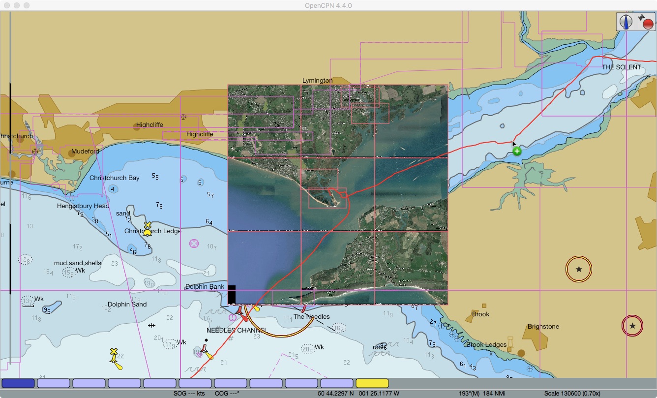
4. Pan and zoom in the image pane to the area of interest.  The red-shaded box shows the area of your chart.  For example here's Hurst Castle in the Solent...

Panned/Zoomed to target area (Hurst Castle in the Solent)
5.  Select the desired options above the image pane:

  • MultiKap = On produces a zip file of 9 tiled images of and around the red-shaded area - use the Tile buttons to see each of the tiles in turn
  • MultiKap = Off produces a single image
  • Format = Zip produces a KAP file (ie not a zip file)
  • Format = KAP produces a file which does not appear to be valid
  • Resolution = Hi produced a good image
  • Resolution = Low produced an image about 1/4 the size of the Hi version

6.  Click on Generate Chart.

Image creation underway
 7.  The file is saved in your Downloads folder.  Move the file to the location where your imagery is read by OpenCPN.  I keep my UK images in /Users/Shared/charts/ge/Europe/UK.  The Windows equivalent would be /Users/Public/charts/ge/Europe/UK.

8.  In OpenCPN go to Options => Charts => Chart Files, tick the "Scan Charts and Update Database" check box and click OK.  When done zoom/pan to the location of your new image charts and check they're there!

Tiled images (array of 9 images) loaded in OpenCPN
9.  For use in SEAiq I suggest combining all imagery for an area in a single zip file.  Then download the zip file to SEAiq.  When running SEAiq on iPad this is done using iTunes as described in my post here.

VentureFarther's web-based satellite chart generation is great.  It makes satellite imagery-based chart creation easy.  I expect to be using it a lot!

Monday, 30 April 2012

Simple Guide to Installing and Using GE2KAP

Hi everyone,
Another geeky post, this one to describe how to use GE2KAP.  GE2KAP is a great utility program which converts whatever you're viewing on Google Earth to a .kap file.  KAP files are charts which can be displayed by the chart plotter software OpenCPN.  GE2KAP is a standalone program, not a "plug-in" to OpenCPN.

This post originally created in April 2012 was updated in August 2013.  Updates in red.

Here's a step by step description of installing, configuring and running GE2KAP...

  1. Download the GE2KAP file on this page.  A .exe file is downloaded.
  2. Run the file (in Windows) which extracts a set of files to a folder you nominate.  Mine is at y:\ge2kap where y: is a shared folder containing all my chart folders and other sailing data folders.
  3. Navigate to y:\ge2kap and check it contains a "Help" folder plus a set of files including "Readme.html" and "GE2KAP.rex".
  4. Double-click on the file "Readme.html" which should open in your browser.  If running on Mac OS X with Windows in a virtual machine, use Finder to open the page in Safari.  y:\ge2kap is /Users/Shared/data/ge2kap on my machine.
  5. The page will show something like "Click here to open the Help file in English and read the Installation section: GE2KAP", with GE2KAP being a link.  Click on the link to load the GE2KAP Help pages.
  6. Click on the Installation => Prerequisites link, and then on the "ooRexx" link to download the oorexx interpreter.  REX is the software language used by GE2KAP.  Follow the rest of the instructions given below this point in the Installation page to install oorexx and Google Earth.
  7. When finished installing all the prerequisites click on the Google Earth link on the left hand side frame in the GE2KAP Help page.  Follow the instructions given there.
  8. When finished click on the Getting Started link on the left hand side frame in the GE2KAP Help page.  Follow the instructions given there.
  9. The GE2KAP Help pages are good, so no need for me to repeat them here.
  10. Recent versions of GE2KAP have included a plugin for OpenCPN (on Windows only).  This is a DLL file which must be manually copied from your GE2KAP folder to your OpenCPN plugins folder.  After copying it run OpenCPN and check it appears in ToolBox => Plugins.
I write all my GE2KAP output files to y:\googleearth.  I suggest creating a new folder to hold your files too, perhaps with sub-folders for geographic regions.

Once installed, using GE2KAP is simply a case of placing what you want in your chart in the Google Earth window, ALT-TAB to the GE2KAP GUI, enter a destination file path/filename and click "Create Chart".  Creation of each chart can take several seconds, so be patient and wait for the GE2KAP GUI transcript to say it completed successfully.

Once you have a couple of charts generated, start OpenCPN and open the ToolBox window.   In the  Settings tab "Enable Chart Quilting" should be ticked.  Click on the Charts tab and in "Available Chart Directories" navigate to y:\googleearth" (or your equivalent) and then click on "Add Directory".  Tick "Force Full Database Rebuild" and click OK.  The chart database will take a few seconds to rebuild.  When complete, pan/zoom to the geographic vicinity of the .kap files you created and you should see a red box for each.  Navigate into the "chart" as normal.  Hey presto!  ;)

Note that you need to either restart OpenCPN or do a Force Full Database Rebuild for new .kap charts to be visible.

The above is a description of how to get started.  I'm no expert and still have plenty to learn!

Monday, 22 December 2025

New Zealand GoogleEarth KML File

Hi everyone,
This is a technical post.   It follows posts on a set of New Zealand OpenCPN waypoints and another on an associated set of KAP 'charts'.  Here we put the waypoints in GoogleEarth itself, providing another means of visualising the places and their surroundings.

Overview

Here are links to the preceding posts:
Here are links to the three folders holding this data on our Dropbox site:
None of this information is for use in navigation!

To use GoogleEarth you can either install the Google Earth Pro app or run Google Earth in your browser.  In either you can load our KMZ file.  Then you can explore the ~550 anchorages, moorings and marinas in our set.

The screenshots below show the waypoints in various popular cruising areas.

Northland

Hauraki Gulf

Abel Tasman and Marlborough Sound

Fiordland

Stewart Island

The GoogleEarth Tour below gives an idea of the detail available, moving from Three Kings Islands in the north to Stewart Island's Port Pegasus in the south via Opua, Auckland, Nelson, Milford Sound and Preservation Inlet.


If you find our KML library useful consider donating using the button at the top of this page.  Alternately Buy Us A Coffee.

Trust all's well where you are!

Thursday, 26 February 2026

Australian, New Zealand and SouthWest Pacific Anchorages

Hi everyone,
This is a technical post.  It follows on from previous posts on Western Australian and New Zealand anchorages.  We've now compiled additional anchorage, mooring and marina waypoints to cover Australia, New Zealand, Fiji, Vanuatu and New Caledonia.

Overview of waypoints in OpenCPN

The new waypoints were compiled from Terry's Topics GPX files and our own research.  Terry's appear to have been provided mainly by SVs Banyandah, Black Duck, Matilda, Olena and SuAn.  Many thanks to them!  We removed most of the many duplicates in Terry's files.  Useful comments and links were retained.  The MinScale parameter was set on most waypoints to avoid obscuring underlying charts - so zoom in to find them all.  And the symbols used were modified to follow our convention.

Our waypoints are also available as KMZ files for GoogleEarth.  The latter are useful for exploring anchorages and marinas in the Google Earth Pro app.  This is especially helpful if you don't have satellite 'charts' installed in OpenCPN.  This of course presumes you have Starlink aboard since Google Earth Pro needs a high-speed internet connection.

With correct setup Google Earth Pro can show your current location via a serial NMEA013 data feed from your boat network.

Our Australian waypoints from Cocos-Keeling to Norfolk Island

Our SouthWest Pacific waypoints for Fiji, Vanuatu & New Caledonia

The screenshot below shows how we arrange our OpenCPN persistent layers.  Each is read from one of our GPX files.  The number of waypoints in each file is shown.  Loading the GPX files as layers avoids inadvertent moving/editing of waypoints.


In addition to our GPX and KML libraries we also have a KAP library.  The KAP library contains satellite 'charts' for use in OpenCPN.

Here are links to the three folders holding this data on our Dropbox site:
None of this information is for use in navigation!

If you find these waypoints useful consider donating using the button at the top of this page.
Alternately Buy us a Coffee!

Trust all's well where you are.

Tuesday, 20 January 2026

Western Australian Anchorages

Hi everyone,
This is a technical post!  It describes a set of 450+ waypoints extracted from the Western Australian Cruising Guide (WACG).  The image below shows the anchorage locations overall.  The WACG covers WA with lesser coverage of western NT and western SA.  It is the WA cruising 'bible'.

Overall Coverage

The WACG is freely available to download here in either ePub or PDF formats.  It has been published by the Cruising Section of Fremantle Sailing Club since 1997.  I have compiled the waypoints from the v5.5 2025 edition.

This set of waypoints is not intended to be a 100% WACG set but I believe it covers 95% or more.  Some waypoints described as 'desperation' anchorages are deliberately omitted.  Likewise some public moorings shown on charts.

WACG Front Cover

As for our New Zealand waypoints, three sets of data are present.  First three GPX files of waypoints (NT, WA & SA) created in OpenCPN.  The waypoints include anchorages, moorings and marinas.  Second a single zip file of KAP satcharts for most of the waypoints.  Third a single KMZ file for use in GoogleEarth.

Below are three GoogleEarth screenshots showing the Kimberley, Pilbara and West/South coast waypoints...

Kimberley

Pilbara

West & South Coasts

Every waypoint includes the WACG v5.5 PDF page number in its description field.  The ScaleMin parameter is set on most GPX waypoints.  This prevents dense sets of waypoints obscuring the underlying charts.  Zoom in to areas of interest to see all waypoints.  The screenshots above show all waypoints.

The accuracy of these waypoints has NOT been verified.
NOT for use in navigation!

The GPX files may be downloaded here.
The three files are named "ZenAgain_Waypoints_Australia_??.gpx".
Each file should be added to OpenCPN as a 'layer'.

The KAP zip file may be downloaded here.
The file is named "Australasia_Australia.zip".
Unzip the file then place the files in a folder searched by OpenCPN for charts.

The KMZ file may be downloaded here.
The file is named "ZenAgain_Waypoints_WACG.kmz".
Load the file in either the Google Earth Pro app or its online equivalent.

Here is a short video tour of WACG waypoints - from Darwin to Port Lincoln via Broome, Exmouth, Fremantle, Augusta and Esperance...


If you find these waypoints useful consider donating using the button at the top of this page.
Alternately Buy us a Coffee!

Trust all's well where you are.