Showing posts with label WindPilot. Show all posts

Saturday, 8 January 2022

Canaries to Antigua Passage Summary

Hi everyone,

Here is a summary of our passage from Mogan on the south coast of Gran Canaria to English Harbour in Antigua.  We departed on Friday 10th December and arrived on Thursday 6th January.  27 days at sea.  The completion of the voyage marked our 'closing the loop' on our North Atlantic / European circuit.

Closed Loop!

First the usual plots...

Route and Track

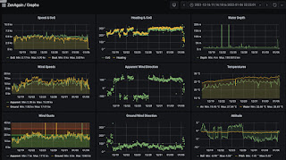
Overview Graph from 16 December to landfall

Speeds ditto (note strong current comes & goes)

Wind Angle ditto (note the three gybes south)

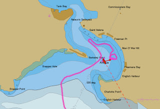
English Harbour Arrival Track

Our route took us SSW to NW of the Cape Verdes, then W to Antigua.  Our track wasn't so simple since we had to zig south several times to avoid predicted windless areas along the route.  We ended as far south as 11 30N.

Performance-wise it was a relatively slow passage.  However we lost only 250nm to a Pacific Seacraft 40 and gained about 400nm on a Tayana 37.  We were all sailing conservatively.  Pretty happy with that.

Here are the vital statistics...

  • Distances/Speeds
    • Route Distance = 2829nm
    • Logged Distance = 2917nm (under-reading due to sargasso weed fouling)
    • GPS Distance = 3237nm
    • Duration = 27 days 3 hours (651 hours)
    • Average boat speed = 4.5kt
    • Average ground speed = 5.0kt
    • Average VMG = 4.3kt
    • Average day's run = 108nm (through the water)
    • Best day's run = 130nm (5.4kt)
    • Minimum boat speed = 2 kt
    • Maximum boat speed = 8 kt (first night in Gran Canaria acceleration zone)
  • Weather
    • Minimum wind speed = 0 kt
    • Average wind speed = 12 knots
    • Maximum wind speed = 35kt (first night in Gran Canaria acceleration zone)
    • Apparent wind angle range = 80 to 140
    • Seas up to 3m
    • Swell up to 2.5m
    • Mostly sunny with periods of cumulus cloud and rain showers
  • Engine
    • Total = 42 hours
    • Driving = 38 hours
    • Charging = 4 hours
  • Consumption
    • Water = 200 litres (7.5 litres / day)
    • Fuel = 50 litres
  • Failures
    • Damaged one heavy duty Harken block due to operator error
  • Stars
    • The boat!
    • WindPilot Pacific vane gear (steered 90% of passage)
    • SailnSea SailingGen hydro generator
    • NMEA-2000/SignalK-based instrumentation system (described here)
    • PredictWind Offshore app (over Iridium GO!) for obtaining GRIBs
    • Icom IC 7300 SSB

We certainly had the expected assistance from current.  Favourable current was very noticeable via the sea state and on our instruments.  We downloaded GRIBs of ocean surface currents from SailDocs and sv Sarana web sites.  These helped us find and stay in favourable current.

Sargasso weed was a hindrance while in water warmer than 27C.  The weed fouled our feathering prop and hydro generator impeller.  The former could be cleared with a brief run of the engine.  The latter by manually lifting the leg and removing the weed.  The weed also deposited critters all over the submerged hull which rapidly developed into 25mm-long 'worms'.  These slowed the boat significantly.  Since arriving we've discovered we weren't alone in having such growths.  The fish here love them, but we're going to have to help them in removing them.

Fouling from Sargasso Weed

We had an SSB sked with several yachts each evening.  They were a daily highlight and propagation was very good indeed.  We spoke with yachts up the River Gambia from mid-Atlantic.  Likewise the Iridium Go! and PredictWind Offshore app GPS Tracking facility kept us in touch with other PW boats - their position and their microblogs.

We were very well fed.  Fresh produce from Mogan lasted 3 weeks plus with very little spoilage.  Fresh meat which we vacuum-packed and refrigerated kept for 2 weeks.  Bread rolls, gingerbread cakes and rum-packed Christmas Cake baked by the Admiral lasted for a shorter time!

Zen Again in English Harbour with the superyachts

Since arriving in English Harbour we've rediscovered the mini supermarket, fresh food market and bakery in or next to the Nelson's Dockyard area.  The mini supermarket sells SIM cards from the carrier Flow.  We bought one month, 40GB cards for about EC240 (approx US$80) each.

We've also been busy starting to clean the hull, doing the laundry, checking the boat and all the other usual post long passage arrival jobs.

Twas a slow passage but a very pleasant one overall.


Saturday, 4 December 2021

Las Palmas to Mogan

Hi everyone,

Yesterday we blasted south from Las Palmas to Mogan.  The two are at opposite ends of Gran Canaria.  Blasted because we rode the 'acceleration zone' around much of the island.  The forecasts said 18G27 at most, while we experienced up to 28G37.  When we rounded the southern tip of the island the wind died completely and we motored the last leg to Mogan.

Awesome sky (with Spanish patrol vessel on horizon)

The tracks and graphs below tell the story.  The heaviest seas were east of the island before we gybed.  The strongest winds were south of the island after we gybed to head west.

Track

Arrival Track

Graphs

Here are the vital stats for the passage…

    • Distances/Speeds
        • Route Distance = 46nm
        • Logged Distance = 53nm
        • GPS Distance = 52nm
        • Duration = 9h30m
        • Average boat speed = 5.6 kt  (7.5 kt until the wind died)
        • Average speed over ground = 5.5 kt  (7.4 kt ditto)
        • Minimum boat speed = 3 kt
        • Maximum boat speed = 11 kt (surf's up)
    • Weather
        • Minimum wind speed = 2 kt
        • Average wind speed = 20 kt
        • Maximum wind speed = gusts over 38 kt (since even the gusts graph is averaged)
        • Apparent wind angle range = 120 to 150
        • Seas up to 3m
        • Swell up to 1.5m
        • Sunny intervals with scattered to broken cumulus cloud
    • Engine
        • Total = 2 hours (motoring 20% of passage)


Leaving Las Palmas at sunrise

We broad reached down the east coast in 20G30 knots of true wind under double-reefed main (= trisail size) and triple furled yankee.  The seas gradually built and we had some good surfs under full control by the WindPilot.  There was a cross sea which occasionally side-swiped us, sending cascades of white water across the boat.  A bit like the trades in the Southern Indian Ocean - for hours not days.

Big seas on the east coast of Gran Canaria

After gybing to broad reach towards the southern cape of Gran Canaria we really got into the acceleration zone.  At about 30 knots steady wind we furled the yankee and unfurled the storm jib / staysail.  It's a similar area to the triple-furled yankee but moves the power down, reducing healing.


Double-reefed main with storm jib / staysail

When the gusts reached the high 30s the WindPilot was starting to lose control.  We were rounded up several times by gusts and seas but but the WindPilot recovered every time.  Nevertheless it indicates it's time to reduce power and move it forward, so we handed the main, leaving just the staysail.  That was much more comfortable and we were still doing 7 knots.  When the true wind exceeds 40 knots we usually broad reach under bare poles at 4-5 knots.  Beyond that it's drogue time.

Storm Jib / Staysail only

Throughout the passage we were taking turns off-watch below.  It's amazing how steady the boat feels below in conditions like this.  Surfing does tend to get one's attention though.

Once past Point Maspaiomas the wind rapidly decreased as we reached the lee of the island.  The NE wind curved around the SE coast for quite a way.  And once past the massive cement works at Point Taozo the wind died completely.  There's a sharp dip in our speeds at that point on the graphs.  We motored for the remaining two hours in  light airs.


Approaching Puerto de Mogan

We called the marina on approach on VHF ch 12.  They asked us to hold outside while the marinaros chose a berth for us.  Communication on the VHF was difficult due to language problems.  Eventually we deciphered that our berth was on the third jetty and proceeded into the marina.  We didn't know which side was ours and waited for 5 minutes while the marinaro had a nice chat with another berth holder.  Eventually he realised we were waiting and we got our instructions.

The marina offers only Med-style slime-line moorings which puts some folk off.  We don't mind them after using them in the Med.  There was very little wind in the marina so backing in to moor stern-to the jetty was fine.

With the boat secured and the light fading we had a quick look around the marina and the adjacent town.  It is plain to see why it is known as 'little Venice' with its waterway through the town.  The lanes are covered with climbing plants in colourful flower including bouganvilla.  And the Christmas lights are out.  Photos in due course!

The passage was a great shakedown for us and Zen Again.  We handled the challenging conditions pretty well and Zen Again was superb as ever.

Trust all's well where you are!


Wednesday, 10 November 2021

La Linea to Porto Santo

Hi everyone,

We arrived in Porto Santo at sunset last night.  The 4.5 day passage was very pleasant overall.  Unusually there were zero tacks and zero gybes.  We had waited in La Linea for a good weather window for both exiting the Gibraltar Strait and the onward passage to the Madeira Islands.

Zen Again at Porto Santo

Our overall and arrival tracks are shown below.  We stayed south of the rhumb line since we expected lighter winds on arrival and wanted a 'hotter' sailing angle for that period.  Worked pretty well.  The winds varied between N and NE during the passage.

Overall Track

Arrival Track

The graphs for the passage are shown below.  The strong tides in the Gibraltar Strait are clearly visible in the Speed & SoG graph.

Graphs
And here are the vital stats for the passage…

    • Distances/Speeds
        • Route Distance = 576nm
        • Logged Distance = 597nm
        • GPS Distance = 592nm
        • Duration = 4d10h (106 hours)
        • Average boat speed = 5.6 kt
        • Average speed over ground = 5.6 kt
        • Minimum boat speed = 4 kt
        • Maximum boat speed = 8 kt
    • Weather
        • Minimum wind speed = 0 kt
        • Average wind speed = 15 kt
        • Maximum wind speed = gusts to 30 kt
        • Apparent wind angle range = 90 to 150
        • Seas up to 2m
        • Swell up to 2m
        • Mostly sunny with scattered small cumulus cloud increasing to broken
    • Engine
        • Total = 13 hours of which 5 for charging (motoring 7.5% of passage)

Our Iridium Go! worked well in providing PredictWind weather forecasts and buddy boat tracks.  The forecasts predicted NNE to ENE winds and were quite accurate.

PredictWind GFS GRIB forecast

The buddy tracking is a relatively new PredictWind service which we hadn't used previously.  It was fun seeing how sv ReVision II and sv Matusadona were doing.  We used email to keep in touch daily, and to post to the blog.

PredictWind GPS Tracks

As the passage progressed the weather gradually improved.  The western approach to the Gibraltar Strait has strong tides which made the sea state less pleasant.  Once clear of the Strait the sea state improved.  And then the wind gradually eased from 20G25 to 15G20, and on the last day 10G15.  It was marvellous to be out on the ocean and chasing sunsets once more.

Chasing the sun around the world (again)

Once we cleared the Strait we engaged the WindPilot (aka Kazi) and it steered us brilliantly until the end of day 3.  The backing and veering of the wind shows clearly in our track.  We disengaged Kazi to test our new SailnSea SailingGen (aka Gen) hydro generator.  It's mounting arrangement is still a work in progress and we can't run it and the WindPilot together for fear of the two colliding.

The SailingGen gave us over 60Ah during a 24 hour run.  During the day its output was limited by the solar panels raising the battery voltage.  This appeared to fool it into thinking the batteries are full.  Need to figure out a way around that.


SailingGen hydro-generator control panel

Approaching Porto Santo reveals the island to be quite 'craggy'.  Reminiscent of King Kong and Jurassic Park albeit on a smaller scale.

Approaching Porto Santo from the East

We arrived just before sunset which allowed us to do a quick motor around the NATO-built harbour.  In addition to the small marina there are a set of moorings and a small area for anchoring.  All looked busy so we anchored outside the harbour which was a little rally but not bad at all.

Apparently boats at anchor in the harbour sheer around a lot so plenty of room and/or short scope is advised.  We noticed a significant chart offset on the CM93 small scale charts when approaching the island.  The large scale CM93 chart of the SE of Porto Santo was fine, as were all Navionics charts.

sv Matusadona at Porto Santo

ReVision II at Porto Santo

Our buddy boats arrived this morning.  We ferried them in to the harbour to clear in.  We'd all previously submitted our Covid certificates to the marina.  They had checked them with local authorities and declared them accepted.  So clearing in involved a visit to the Marina office and the Police, both in the same building.

It's fantastic to be out in the Atlantic again!


Friday, 22 October 2021

Cartagena to La Linea

Hi everyone,

We arrived in La Linea last night after a 60 hour passage from Cartagena.  We had a great 9 day stay there.  The stay was quite social and we enjoyed further exploring the city.  The passage to La Linea was good for the Med with 2/3 of the time sailing.  We had some great sailing, and some challenging sailing too.  Two knots of adverse current while sailing downwind in 25 knots of breeze produced a very unpleasant sea state.  We also came upon an abandoned inflatable boat.

Abandoned Boat

We took the first reasonable weather window from Cartagena after waiting a week for a package which didn't materialise.  The weather window promised at least 36 hours of easterly breeze.  The breeze came in 6 hours after we departed Cartagena.  The track below shows we crossed the shipping lanes twice.  That kept us busy!  Once north of the lanes again we stayed so, gybing north to remain clear of the traffic.

Track

The graphs below show many things but the most interesting is the current we experienced.  The current is well known to flow strongly into the Med through the Gibraltar Straits.  The current flow extends well into the Med.  We had up to 2.5 knots of current against us for the second half of the passage.  This included the period in which we had 25 knots of easterly.  To make things even more interesting we sailed over a sea mount.  Even at 300m deep it seemed to significantly affect the sea state.

Graphs

The speeds graph below clearly shows the adverse current which added 32nm to the passage, or about 6 hours.

Boat Speed and Ground Speed

And here are the vital stats for the passage…

    • Distances/Speeds
        • Route Distance = 244nm
        • Logged Distance = 309nm
        • GPS Distance = 277nm
        • Duration = 2d12h (60 hours)
        • Average boat speed = 5.1 kt
        • Average speed over ground = 4.6 kt
        • Minimum boat speed = 3 kt
        • Maximum boat speed = 8 kt
        • Note the 32 nm lost to adverse current!
    • Weather
        • Minimum wind speed = 0 kt
        • Average wind speed = 15 kt
        • Maximum wind speed = gusts to 31 kt
        • Apparent wind angle range = 0 to 150
        • Seas up to 2m
        • Swell up to 2m
        • Mostly clear skies with a full moon!
    • Engine
        • Total = 22 hours (37% of passage)

We departed Cartagena in very light winds.  After about 4 hours motoring we spotted what appeared to be a drifting boat.  We altered course to investigate and found it was a new-looking inflatable boat, about 7m in length.  There was no one aboard, no motor, clothes lying in the bilge and one oar.  A set of numbers were painted on the hull.

We called Cartagena Radio and gave them its position and description.  They called us back saying we could proceed on our passage.  We inferred the boat had been intercepted and people (and the engine) taken off by the Spanish coastguard.  They probably painted the numbers.

Farewell Cartagena

A couple of hours later we had a sailing breeze which steadily filled in to become a 20-25 knot easterly. We gradually reefed down until we had a trisail-sized main (2 reefs in our cruising main) and three furls in the yankee.  Initially we were doing 6+ knots over the ground.  Gradually this reduced to 4 knots as we entered the adverse current.  We used the WindPilot for much of the passage and it handled the difficult conditions beautifully.

WindPilot in charge and lovin' it

On our second evening at sea we were joined by a pod of small dolphins.  They stayed with us all night and reappeared the following evening as we approached Gibraltar.  It's always nice to have a friendly escort!

Small Dolphin Leaping

Still Leaping at Sunset

On day 3 the winds gradually died and the engine eventually went back on.  With our diesel supplies running low we transferred our last jerry contents into the main tanks.  We've been running down our fuel level so as to refill cheaply in Gibraltar.

Approaching Gibraltar

We motored quietly into Gibraltar Bay mid-evening.  Twas interesting avoiding everything from large cargo vessels coming to anchor to tiny fishing boats.  We anchored off Alcaidesa Marina for the night.

Dawn anchored off Alcaidesa Marina, La Linea

This morning we motored around to Gibraltar's fuel jetty and took on 180 litres of diesel.  Now we're heading out of the Med our full 240 litres should keep us going for some time.  From the fuel dock we returned to Alcaidesa and entered the marina.

Refuelling @77p/litre

We expect to stay here in La Linea for a week or so.  Hopefully our packages will catch up with us - we're looking forward to having a working RodKicker again!

Saturday, 5 June 2021

Portimao to Tarifa

Hi everyone,

This was a passage of two parts.  Before the Strait of Gibraltar, and in it.  The first part was a very pleasant sail.  The second was challenging.  The Strait hadn't got the memo and decided to blow 20+ knots from the east instead of variable winds to 10 knots.  And we arrived at the start of the foul tidal current.  In the Strait we copped red dusty rain from the rainstorms - presumably Saharan dust!

Sunset astern - heading east!

Here are the plots...

Track

Arrival Track Detail

Graphs

And here are the vital stats for the passage…

    • Distances/Speeds
        • Route Distance = 158nm
        • Logged Distance = 147nm (log still under-reading)
        • GPS Distance = 181nm
        • Duration = 37.5 hours
        • Average speed over ground = 4.8 kt
        • Minimum boat speed = 4 kt
        • Maximum boat speed = 7 kt
    • Weather
        • Minimum wind speed = calm
        • Average wind speed = 15 kt
        • Maximum wind speed = gusts to 30 kt
        • Apparent wind angle range = 40 to 160
        • Seas up to 1.5m
        • Swell up to 1m
        • Cloudless before the Strait then cloudy with poor visibility and showers
    • Engine
        • Total = 10 hours

Day 1 was very pleasant with lightish breezes but mostly enough to keep Zen Again moving nicely.  We only motored for an hour during a very light patch.  Overnight we played cat and mouse with several AIS-less fishing boats which appeared to like staying within a mile of us regardless of our changes of course.  Our new radar was very helpful in showing their range.

Sunny Day One

At midnight we gybed east as the wind veered into the NW.  By dawn the wind had swung into the NNE and then died.  We motored on and off all morning.  As we entered the Strait of Gibraltar we started to feel the adverse W current.  And we were dodging rainstorms over the strait.

Approaching the Strait

Our track and graphs below tell the story.  The first 'zig' north was when E winds started.  We briefly considered pulling in to Barbate but the 20 knot wind decreased to 15 knots and we decided to press on. Once SE of Barbate of course the wind kicked back up!  For several hours we had over 20 knots of breeze.  The WindPilot handled it perfectly.

Track in the Strait

We tacked E into the foul current.  Zen Again loved it. And once we saw the boat was handling it well we were OK with it too.  Very like sailing south down the Western Australian coast, but with a foul current.  The Strait's shipping lanes greatly reduce manoeuvring room, forcing us to short-tack along the north side of the Strait.  And the nasty shoals W of Tarifa didn't help either.

Graphs in the Strait

As sunset approached the wind was decreasing rapidly.  We decided to anchor in the lee of Tarifa for the night, hoping the wind in the morning would be kind!  Tarifa is 18nm WSW of Gibraltar and an excellent place to shelter from the Strait's frequent E gales.

So we're nearly in the Med, and we avoided the Orcas!  See the Iberian Orca web site here.

Tuesday, 4 August 2020

Studland Bay to Helford River

Hi everyone,
Last Thursday we departed Studland Bay after several days.  We did an overnighter to the Helford River, using a rare easterly to get us there in style (ie downwind).

The time spent at Studland Bay was occupied with fixing the engine, relaxing, then rewatering.  Day 1 was breezy and cloudy but then it cleared up.  See the postscript to our previous blog for details of the engine fix.  On day 2 the RAF entertained us with an air drop from a C-130 Hercules.  On day 3 we moved Zen Again closer to the shore, then did several runs ashore in the dinghy to fill our fresh water tanks and jerries.

Sunset in Studland Bay

RAF entertains over Studland Bay

We waited in Studland Bay since we knew a day of easterlies was coming.  The prediction was for 15 knot E winds on Thursday, decreasing overnight and swinging through S into the W on Friday.

Departure Weather

Arrival Weather

Here's our track...

Zen Track

And here are the usual stats...
  • Distances/Speeds
    • Route Distance = 135nm
    • GPS Distance = 155nm
    • Duration = 28h
    • Average Ground Speed = 5.5 knots
  • Weather
    • Minimum Wind Speed = 0 knots
    • Maximum Wind Speed = 15 knots
    • Apparent Wind Angle Range = 0 to 140 degrees
    • Seas up to 1.5m
    • Sunny!
  • Engine
    • Total = 5 hours
    • Driving = 5 hours
And here are the plots, created from our NMEA-2000 network using SignalK, InfluxDB and Grafana...

Graphs

Speeds

Wind Speeds

The speed plot show tidal currents basically cancelled out over the passage, as one would expect for a 24 hour passage.  The wind speed plot shows we maintained the apparent wind pretty well.

Beating south from Studland Bay

The WindPilot steered while we were sailing, which was most of the passage.  We were very happy at how well in handled the light airs.

WindPilot in action

Reaching towards Portland under full sail

Unusually long range on VHF & AIS

Broad reaching WSW

Overnight the winds lightened.  We eventually decided to gybe north since keeping a sailable apparent wind had taken us well south.  Before dawn the left-over sea from the E and the Atlantic swell from the W were creating a washing machine sea state.  Our sails were slatting so it was time to motor and turn west.

Sunrise in very light winds

As we motored along we encountered several 'mist banks' - thin cloud at sea level.  We could see them coming but it was surreal motoring through them and back out into bright sunshine.

Dolphin escort while motoring west in calm conditions

By breakfast time we were sailing again, beating our way towards the mouth of the Helford River.

Sailing again in a light WSW wind

We motored into the Helford River.  By that time it was cloudy.  We motored through the Pool then back to the E end where we picked up a visitor's mooring.  We were last in the Helford River during a charter with my Uncle Ian in 2000.  Many more moorings now but just as pretty.

Entering the pool in the Helford River

Helford

We spent three nights on the Helford River.  More on that in our next post!