Today we sailed from Deep Bay on Antigua to Cocoa Point on Barbuda. It was our first close-hauled passage since we approached Gibraltar from Portimao last year. The boat went well and the crew hung on!
The wind was more NE than the ENE it was supposed to be. And as expected there was a 1 knot W current, requiring us to head up as high as possible to lay the island. We sailed under 1 reef and 3 furls which kept things comfortable.
A couple of large yachts came tramping past doing 10 knots. One of them even tried to climb over us - what a b#E%^$d!!! But Kazi the WindPilot calmly pinched him out and he ducked below us when only a few boat lengths behind.
Here are the usual graphs…
Track

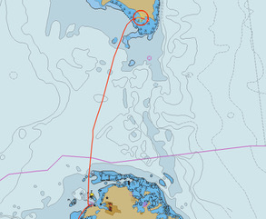
Arrival Track

Graphs
And a few stats…
* Time = 5h30m * Route = 27nm
* Track = 28nm
* Log = 28nm
* Average Boat Speed = 5.1kt
* Average Ground Speed = 5.1kt
The arrival track image shows a GoogleEarth KAP chart since our marine chart in OpenCPN isn't very accurate. The Navionics chart on our iPads is better and notes indicate the coast of Barbuda, particularly the west coast, was heavily impacted by Hurricane Irma a few years ago. We encountered no bombies and had 6m all the way in to the anchorage. We are anchored in 5m over sand at 17 33.07N 061 46.17W.
In the anchorage there are about a dozen yachts. Two of them are superyachts. There are also two massive motoryachts. Ashore are exclusive resorts and a number of new buildings under construction.
Unexpectedly, there is no mobile phone coverage here at Cocoa Point. So we're sending this via our Iridium Go!. Those of you expecting emails from us - please check your Junk/Spam folders for emails from our satphone.me accounts.
Trust all's well where you are.
No comments:
Post a Comment