Hi everyone,
We arrived in Puerto Obaldia, Panama at 1730 last night, 15 minutes before sunset. It was a great passage with good winds throughout.
 |
| Panama Ho! |
Here are the usual plots...
 |
| Overall Track |
 |
| Arrival Detail |
 |
| Graphs |
Our track took us past the mouth of the Magdelena River. We stayed 12nm off the coast there. We continued west until north of a projected S-flowing current. We gybed there and made good progress south. First however we had adverse current but positive current appeared and pushed us south all the way. The wind varied as we progressed south so reefs came out and went back in several times. We motored the last few miles as the wind gradually died.
Here are the vital statistics...
- Distances/Speeds
- Route Distance = 293nm
- Log Distance = 297nm
- Track Distance = 297nm
- Duration = 2 days 6 hours (54 hours)
- Average boat speed = 5.5kt
- Average ground speed = 5.5kt
- Average day's run = 134nm (through the water)
- Best day's run = 134nm (5.5 kt)
- Minimum boat speed = 4 kt
- Maximum boat speed = 7 kt
- Weather
- Minimum wind speed = 4 kt
- Average wind speed = 15 knots
- Maximum wind speed = 31kt
- Apparent wind angle range = 100 to 170
- Seas up to 2.5m
- Swell negligible
- Mostly sunny with a few small cumulus. A couple of light showers.
- Engine
- Failures
- Stars
- The boat!
- Starlink for accessing GRIB files and email
- SailnSea SailingGen hydro generator
- Icom IC-7300 SSB for 12 hourly position reporting net with friends
The Puerto Obaldia anchorage provided good holding in 9m over silty mud. Overnight a couple of rainstorms came through and we stayed put. At other times however the wind dropped out and we were left rolling heavily beam-on to the seas. Not much fun!
 |
| Zen Again at Puerto Obaldia |
 |
| View from the Police Jetty |
This morning sv Cerulean and sv Avanti arrived and anchored nearby. We went ashore in our dinghy and visited the police, immigration, maritime administration and back to the police. At the end of that, and US$260 poorer, we were cleared in to Panama for 3 months with a cruising permit for the whole country.
We had a quick look around the town. It's very much a border town with many government offices and substantial police presence. But everyone was friendly despite our limited Spanish. We found hardware, clothes and general stores.
Back on Zen Again we hoisted the dinghy aboard and weighed anchor. We didn't want to spend another night in that anchorage! 3 1/2 hours later we were in Puerto Oscoses, about 20nm west. This is a very nice bay with calm seas. Anchored in 8m over silty mud at 08 49.7N 077 38.0W.
 |
| Motoring west along the coast |
 |
| In Panama! |
There was very little wind so we motored along the coast. Very jungly!
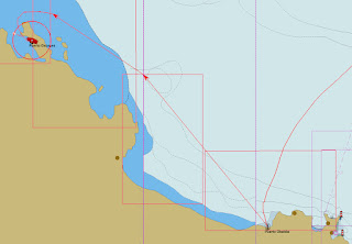 |
| Overall Route |
 |
| Arrival Detail |
 |
| Graphs |
 |
| Puerto Escoses |
From here we expect to travel westward through the San Blas islands. But first, a good night's sleep!


No comments:
Post a Comment